Comprehensive plan update: June 2026
Community Update:
Your voice matters! The draft of our Comprehensive Plan Update is now open for public feedback from June 23 through July 24. This plan guides our community's future growth, development, and infrastructure priorities.
How to Participate:
- Review: Examine the Comprehensive Plan Update document, Implementation Matrix, and Future Land Use Map.
- Respond: Share your feedback in our official online survey.
Review the Plan and Take the Survey. Click here for the survey.
Comprehensive plan update: April 2026
Explore the summary results from the Comprehensive Plan Update Survey. Click here for full results.
Public Input Summary (Transcribed from March 23 public input meeting). Click here to learn more.
Comprehensive plan update: march 2026
Explore the summary results from the Comprehensive Plan Update Survey. Full results will be available in Part 2 in April 2026. Click here to learn more.
Comprehensive plan update: October 2025
The Comprehensive Plan Online Survey closed January 16, 2026.
What is a Comprehensive Plan?
A comprehensive plan is a long-range roadmap for the future of a community which examines and makes recommendations on a variety of planning activities such as land use, transportation, utilities, infrastructure, community facilities, housing, the environment, recreation, economic development, and more. It provides information about conditions, trends and issues in a community and identifies actions needed to address such issues.
A comprehensive plan is not a regulatory document on its own. Rather, it establishes goals and priorities that guide future growth and development. It also:
- Documents a community conversation: “Where are we today? Where would we like to be?”
- Provides a basis for decision-making, problem-solving and policy development by government officials.
- Establishes priorities for government projects, staff, and services.
It also asks:
- How much growth?
- Where should new development occur?
- What kind of development should be supported?
- What level of intensity is appropriate for future development and redevelopment?
Why do we need to update the Comprehensive Plan?
The existing Comprehensive Plan was adopted by Town Council on July 16, 2016, with a ten-year horizon running through 2026. The existing plan suggests needing to be updated every 5 to 10 years in response to land use trends, changes in population, or any major events that may affect Laurel Park’s future. As a condition of adopting and applying zoning regulations, North Carolina General Statute 160D states that a local government shall adopt and reasonably maintain a comprehensive plan. While the statutes do not specifically define the time frame needed to reasonably maintain the Plan, the University of North Carolina School of Government says, in general, professional practice calls for plans to be updated every five to ten years.
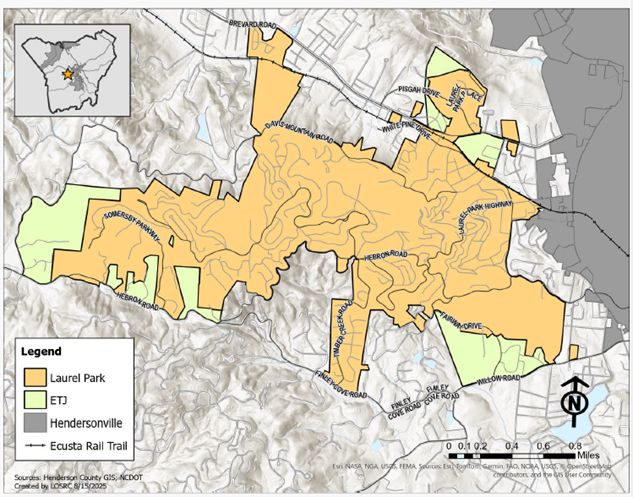
What is a Study Area?
The Laurel Park Comprehensive Plan Update will make recommendations for the community based on a Study Area. The Laurel Park Study Area includes the town limits of Laurel Park and its extraterritorial jurisdiction. The ETJ is not within the town limits. However, Laurel Park has legal authority to extend its zoning and development regulations into this area though these parcels are not assessed for Laurel Park property tax.
Laurel Park Study Area (Laurel Park and its ETJ)
How can I participate?
The Comprehensive Plan Online Survey closed January 16, 2026.
If you live in the Study Area, this survey represents your voice and vision for the next 10+ year. Your responses will assist Laurel Park with updating its Comprehensive Plan. by identifying community strengths, weaknesses, and goals within Laurel Park’s Study Area. When answering this survey, please consider that Laurel Park is in recovery after Hurricane Helene; repairing damaged roads and essential infrastructure are a current priority.
- You do not have to complete the entire survey to submit it.
- A public input meeting will be held March 23, 2026, from 5:00 pm to 7:00 pm, at the First Congregational Church, 1735 5th Ave. West, Hendersonville, NC 28739.
For more information, please contact Alexis Baker, Regional Planner, at the Land of Sky Regional Council at 828-378-7746 or